
Xã Thanh Sơn topographic map
Interactive map
Click on the map to display elevation.
About this map
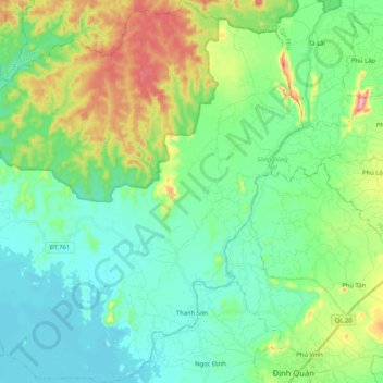
Name: Xã Thanh Sơn topographic map, elevation, terrain.
Location: Xã Thanh Sơn, Định Quán District, Đồng Nai Province, Vietnam (11.19345 107.15882 11.39717 107.35787)
Average elevation: 410 ft
Minimum elevation: 167 ft
Maximum elevation: 1,096 ft
Other topographic maps
Click on a map to view its topography, its elevation and its terrain.
Định Quán
Vietnam > Dong Nai province > Định Quán District
Định Quán, Định Quán District, Đồng Nai Province, Vietnam
Average elevation: 463 ft