
Big Creek topographic map
Interactive map
Click on the map to display elevation.
About this map
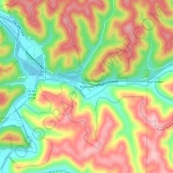
Name: Big Creek topographic map, elevation, terrain.
Location: Big Creek, Clay County, Kentucky, 40914, United States (37.14231 -83.58880 37.18231 -83.54880)
Average elevation: 1,161 ft
Minimum elevation: 801 ft
Maximum elevation: 1,499 ft
Other topographic maps
Click on a map to view its topography, its elevation and its terrain.
Oneida
United States > Kentucky > Clay County
Oneida, Clay County, Kentucky, United States
Average elevation: 974 ft
Littleton
United States > Kentucky > Clay County
Littleton, Clay County, Kentucky, 40962, United States
Average elevation: 1,033 ft
Sextons Creek
United States > Kentucky > Clay County
Sextons Creek, Clay County, Kentucky, 40983, United States
Average elevation: 1,020 ft
Fall Rock
United States > Kentucky > Clay County
Fall Rock, Clay County, Kentucky, United States
Average elevation: 1,129 ft
Manchester
United States > Kentucky > Clay County
Manchester, Clay County, Kentucky, 40962, United States
Average elevation: 1,033 ft
Vine
United States > Kentucky > Clay County
Vine, Clay County, Kentucky, United States
Average elevation: 1,099 ft