Geolocate

Rama topographic map

Click on the map to display elevation.

About this map

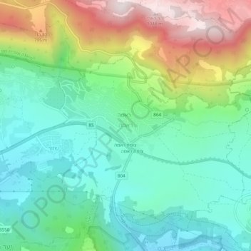
Name: Rama topographic map, elevation, terrain.

Location: Rama, Rameh, Acre Subdistrict, North District, Israel (32.91639 35.34722 32.95639 35.38722)

Average elevation: 1,598 ft

Minimum elevation: 732 ft

Maximum elevation: 3,422 ft

Gear up for your next adventure:

🪓Survival Multi‑Tool - Versatile tool for camp and trail tasks
🥤Water Filter Bottle - All‑in‑one filter bottle for safe hydration
🪶Thermal Camp Blanket - Extra warmth for cold nights
🪄Magnetic Compass - Accurate compass for navigation
🚪Portable Camp Chair - Foldable chair for comfort at camp

As an Amazon Associate, this site earns from qualifying purchases at no extra cost to you.