
Thank you for supporting this site ❤️
Make a donation
Make a donation
Gear up for your next adventure:
As an Amazon Associate, this site earns from qualifying purchases at no extra cost to you.
Farfa topographic map
Click on the map to display elevation.
Thank you for supporting this site ❤️
Make a donation
Make a donation
Gear up for your next adventure:
As an Amazon Associate, this site earns from qualifying purchases at no extra cost to you.
About this map
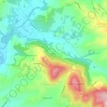
Name: Farfa topographic map, elevation, terrain.
Location: Farfa, Prime Case, Fara in Sabina, Rieti, Lazio, 02032, Italia (42.20085 12.69812 42.24085 12.73812)
Average elevation: 741 ft
Minimum elevation: 246 ft
Maximum elevation: 1,778 ft
Thank you for supporting this site ❤️
Make a donation
Make a donation
Gear up for your next adventure:
As an Amazon Associate, this site earns from qualifying purchases at no extra cost to you.