
Make a donation
Gear up for your next adventure:
As an Amazon Associate, this site earns from qualifying purchases at no extra cost to you.
Skyline View topographic map
Click on the map to display elevation.
Make a donation
Gear up for your next adventure:
As an Amazon Associate, this site earns from qualifying purchases at no extra cost to you.
About this map
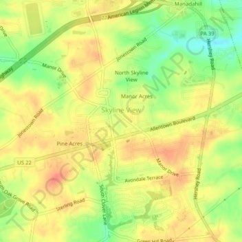
Name: Skyline View topographic map, elevation, terrain.
Average elevation: 499 ft
Minimum elevation: 404 ft
Maximum elevation: 558 ft
Dauphin County trails, hiking, mountain biking, running and outdoor activities
Make a donation
Gear up for your next adventure:
As an Amazon Associate, this site earns from qualifying purchases at no extra cost to you.
Other topographic maps
Click on a map to view its topography, its elevation and its terrain.
Piketown
United States > Pennsylvania > Dauphin County > West Hanover Township
Average elevation: 640 ft
Hanoverdale
United States > Pennsylvania > Dauphin County > West Hanover Township
Average elevation: 469 ft