
Make a donation
Gear up for your next adventure:
As an Amazon Associate, this site earns from qualifying purchases at no extra cost to you.
Woodbury topographic map
Click on the map to display elevation.
Make a donation
Gear up for your next adventure:
As an Amazon Associate, this site earns from qualifying purchases at no extra cost to you.
About this map
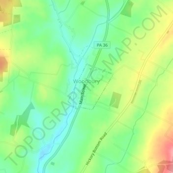
Name: Woodbury topographic map, elevation, terrain.
Location: Woodbury, Bedford County, Pennsylvania, United States (40.22199 -78.37048 40.22916 -78.36125)
Average elevation: 1,325 ft
Minimum elevation: 1,201 ft
Maximum elevation: 1,519 ft
Bedford County trails, hiking, mountain biking, running and outdoor activities
Make a donation
Gear up for your next adventure:
As an Amazon Associate, this site earns from qualifying purchases at no extra cost to you.
Other topographic maps
Click on a map to view its topography, its elevation and its terrain.
Riddlesburg
United States > Pennsylvania > Bedford County > Broad Top Township
Average elevation: 1,224 ft
Loysburg
United States > Pennsylvania > Bedford County > South Woodbury Township
Average elevation: 1,391 ft
Make a donation
Gear up for your next adventure:
As an Amazon Associate, this site earns from qualifying purchases at no extra cost to you.
Fishertown
United States > Pennsylvania > Bedford County > East Saint Clair Township
Average elevation: 1,293 ft
Clearville
United States > Pennsylvania > Bedford County > Monroe Township
Average elevation: 1,414 ft
Buffalo Mills
United States > Pennsylvania > Bedford County > Harrison Township
Average elevation: 1,558 ft
Make a donation
Gear up for your next adventure:
As an Amazon Associate, this site earns from qualifying purchases at no extra cost to you.
Earlston
United States > Pennsylvania > Bedford County > West Providence Township
Average elevation: 1,184 ft
Patience
United States > Pennsylvania > Bedford County > Cumberland Valley Township
Average elevation: 1,522 ft
Hewitt
United States > Pennsylvania > Bedford County > Southampton Township > Hewitt
Average elevation: 1,132 ft
Make a donation
Gear up for your next adventure:
As an Amazon Associate, this site earns from qualifying purchases at no extra cost to you.
Yellow Creek
United States > Pennsylvania > Bedford County > Hopewell Township > Yellow Creek
Average elevation: 1,125 ft