
Make a donation
Gear up for your next adventure:
As an Amazon Associate, this site earns from qualifying purchases at no extra cost to you.
Lúčky topographic map
Click on the map to display elevation.
Make a donation
Gear up for your next adventure:
As an Amazon Associate, this site earns from qualifying purchases at no extra cost to you.
Lúčky
The village lies at an altitude of 107 metres and covers an area of 7.92 km2 (3.06 sq mi) (2020-06-30/-07-01).
Make a donation
Gear up for your next adventure:
As an Amazon Associate, this site earns from qualifying purchases at no extra cost to you.
About this map
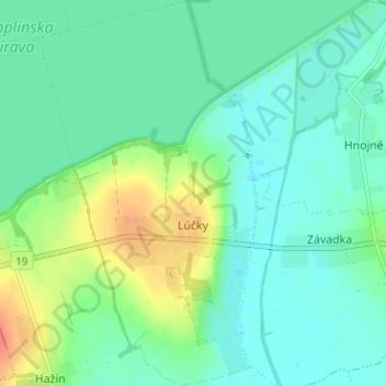
Name: Lúčky topographic map, elevation, terrain.
Average elevation: 371 ft
Minimum elevation: 328 ft
Maximum elevation: 469 ft
Make a donation
Gear up for your next adventure:
As an Amazon Associate, this site earns from qualifying purchases at no extra cost to you.
Other topographic maps
Click on a map to view its topography, its elevation and its terrain.
Markovce
Slovakia > Region of Košice > District of Michalovce > Markovce > Markovce
Average elevation: 338 ft
Michalovce
Slovakia > Region of Košice > District of Michalovce > Michalovce > Michalovce
Average elevation: 371 ft