Geolocate

Oroso topographic map

Click on the map to display elevation.

About this map

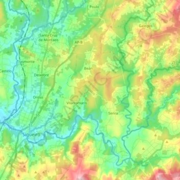
Name: Oroso topographic map, elevation, terrain.

Location: Oroso, Ordes, A Coruña, Galicia, Spain (42.95449 -8.46909 43.04554 -8.29584)

Average elevation: 965 ft

Minimum elevation: 712 ft

Maximum elevation: 1,480 ft

Other topographic maps

Click on a map to view its topography, its elevation and its terrain.

Hospital

Spain > Galicia > Ordes

Average elevation: 1,325 ft

Cruz de Nouche

Spain > Galicia > Ordes > Beán

Average elevation: 1,024 ft

Meitufe do Medio

Spain > Galicia > Ordes > Ordes

Average elevation: 1,257 ft

O Canedo

Spain > Galicia > Ordes

Average elevation: 1,234 ft

Gear up for your next adventure:

🛰️Satellite Messengers - Emergency SOS and two-way messaging for off-grid adventures
🧭Hiking Compass - Precision compass for reliable navigation in the wilderness
🎁Geography Themed Gifts - Unique gift ideas for map lovers and geography enthusiasts
Camping Coffee Makers - Enjoy premium coffee at the summit or campsite
🦟Ultrasonic Repellers - Create a bug-free zone at your camp or rest stop

As an Amazon Associate, this site earns from qualifying purchases at no extra cost to you.