
Thank you for supporting this site ❤️
Make a donation
Make a donation
Gear up for your next adventure:
As an Amazon Associate, this site earns from qualifying purchases at no extra cost to you.
Amoreira topographic map
Click on the map to display elevation.
Thank you for supporting this site ❤️
Make a donation
Make a donation
Gear up for your next adventure:
As an Amazon Associate, this site earns from qualifying purchases at no extra cost to you.
About this map
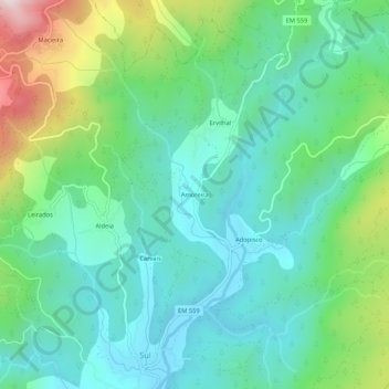
Name: Amoreira topographic map, elevation, terrain.
Location: Amoreira, Sul, São Pedro do Sul, Viseu, 3660-615, Portugal (40.83228 -8.05559 40.87228 -8.01559)
Average elevation: 1,329 ft
Minimum elevation: 741 ft
Maximum elevation: 2,966 ft
Thank you for supporting this site ❤️
Make a donation
Make a donation
Gear up for your next adventure:
As an Amazon Associate, this site earns from qualifying purchases at no extra cost to you.