
Thank you for supporting this site ❤️
Make a donation
Make a donation
Gear up for your next adventure:
As an Amazon Associate, this site earns from qualifying purchases at no extra cost to you.
Torres topographic map
Click on the map to display elevation.
Thank you for supporting this site ❤️
Make a donation
Make a donation
Gear up for your next adventure:
As an Amazon Associate, this site earns from qualifying purchases at no extra cost to you.
About this map
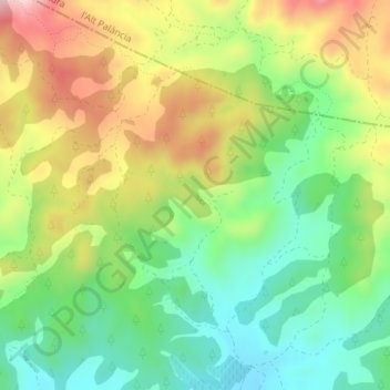
Name: Torres topographic map, elevation, terrain.
Location: Torres, Llíria, el Camp de Túria, Valencia, Spanje (39.73002 -0.64645 39.75002 -0.62645)
Average elevation: 1,463 ft
Minimum elevation: 1,109 ft
Maximum elevation: 1,955 ft
Thank you for supporting this site ❤️
Make a donation
Make a donation
Gear up for your next adventure:
As an Amazon Associate, this site earns from qualifying purchases at no extra cost to you.