
Make a donation
Gear up for your next adventure:
As an Amazon Associate, this site earns from qualifying purchases at no extra cost to you.
Tualatin River topographic map
Click on the map to display elevation.
Make a donation
Gear up for your next adventure:
As an Amazon Associate, this site earns from qualifying purchases at no extra cost to you.
Tualatin River
The drainage area of the river is approximately 712 square miles (1,840 km2) with 27 creeks feeding into the Tualatin. Its watershed is 15 percent urbanized, 35 percent agricultural, and 50 percent forested. The river drops 1,800 feet (550 m) in elevation during its first 12 miles (19 km) and then only an additional 250 feet (76 m) for the remaining 71 miles (114 km) of its course. This creates a slow river for the majority of the course, creating problems with pollution. Pollution reached a point that in 1989 local agencies were forced to begin cleaning up the river after the Tualatin failed water quality standards outlined in the Clean Water Act of 1972. It was the first river in the state to fail overall pollution limits.
Make a donation
Gear up for your next adventure:
As an Amazon Associate, this site earns from qualifying purchases at no extra cost to you.
About this map
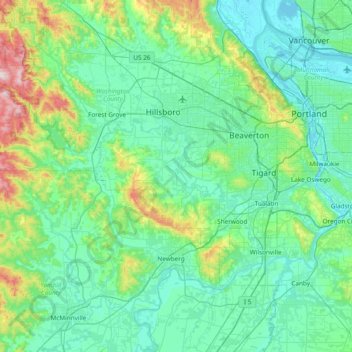
Name: Tualatin River topographic map, elevation, terrain.
Location: Tualatin River, Washington County, Oregon, United States (45.33804 -123.40799 45.51229 -122.64732)
Average elevation: 384 ft
Minimum elevation: -10 ft
Maximum elevation: 2,428 ft
Washington County trails, hiking, mountain biking, running and outdoor activities
Make a donation
Gear up for your next adventure:
As an Amazon Associate, this site earns from qualifying purchases at no extra cost to you.
Other topographic maps
Click on a map to view its topography, its elevation and its terrain.
Make a donation
Gear up for your next adventure:
As an Amazon Associate, this site earns from qualifying purchases at no extra cost to you.
Vern Galaway Memorial Park
United States > Oregon > Washington County > North Plains
Average elevation: 184 ft