
Make a donation
Gear up for your next adventure:
As an Amazon Associate, this site earns from qualifying purchases at no extra cost to you.
Oliver topographic map
Click on the map to display elevation.
Make a donation
Gear up for your next adventure:
As an Amazon Associate, this site earns from qualifying purchases at no extra cost to you.
About this map
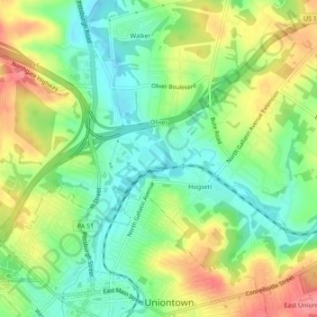
Name: Oliver topographic map, elevation, terrain.
Average elevation: 1,050 ft
Minimum elevation: 932 ft
Maximum elevation: 1,214 ft
Fayette County trails, hiking, mountain biking, running and outdoor activities
Make a donation
Gear up for your next adventure:
As an Amazon Associate, this site earns from qualifying purchases at no extra cost to you.
Other topographic maps
Click on a map to view its topography, its elevation and its terrain.
Mount Braddock
United States > Pennsylvania > Fayette County > North Union Township
Average elevation: 1,302 ft
Lemont Furnace
United States > Pennsylvania > Fayette County > North Union Township
Average elevation: 1,220 ft
Jumonville
United States > Pennsylvania > Fayette County > North Union Township > Jumonville
Average elevation: 2,011 ft