
Make a donation
Gear up for your next adventure:
As an Amazon Associate, this site earns from qualifying purchases at no extra cost to you.
Mehrhoog topographic map
Click on the map to display elevation.
Make a donation
Gear up for your next adventure:
As an Amazon Associate, this site earns from qualifying purchases at no extra cost to you.
Mehrhoog
Der Ortsnamenteil Mehr sagt, dass der Ort in der Nähe eines Meers, eines früheren Rheinarms, liegt. Hoog bedeutet höher. Mehrhoog ist also der höher liegende Teil des alten Ortes Mehr.
Make a donation
Gear up for your next adventure:
As an Amazon Associate, this site earns from qualifying purchases at no extra cost to you.
About this map
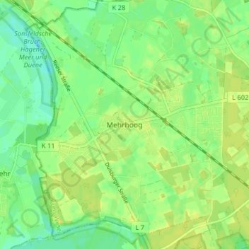
Name: Mehrhoog topographic map, elevation, terrain.
Average elevation: 69 ft
Minimum elevation: 36 ft
Maximum elevation: 89 ft
Make a donation
Gear up for your next adventure:
As an Amazon Associate, this site earns from qualifying purchases at no extra cost to you.
Other topographic maps
Click on a map to view its topography, its elevation and its terrain.
Dingdener Heide
Deutschland > Nordrhein-Westfalen > Kreis Wesel > Hamminkeln
Average elevation: 161 ft