
Sbeitla topographic map
Interactive map
Click on the map to display elevation.
About this map
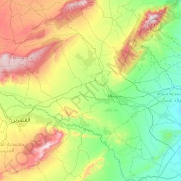
Name: Sbeitla topographic map, elevation, terrain.
Location: Sbeitla, Kasserine, 1250, Tunisie (35.00889 8.79915 35.47540 9.32389)
Average elevation: 2,241 ft
Minimum elevation: 1,175 ft
Maximum elevation: 4,505 ft
Other topographic maps
Click on a map to view its topography, its elevation and its terrain.
El Khadhra
El Khadhra, Kasserine Nord, Kasserine, Tunisie
Average elevation: 2,224 ft