
Make a donation
Gear up for your next adventure:
As an Amazon Associate, this site earns from qualifying purchases at no extra cost to you.
Marbella topographic map
Click on the map to display elevation.
Make a donation
Gear up for your next adventure:
As an Amazon Associate, this site earns from qualifying purchases at no extra cost to you.
Marbella
There are five geomorphological areas in Marbella—the Sierra Blanca, the Sierra Blanca piedmont (foothills), the lower hill country, the plains and the coastal dunes. The Sierra Blanca is the most centrally-located in the province, peaking behind the old village. The mountain range has three notable peaks—La Concha, located further west at 1,215 m (3,986 feet) above sea level, Juanar Cross, located eastward (within the municipality of Ojen) at 1,178 m (3,865 feet) above sea level, and the highest, Mount Lastonar, located between the two at 1,270 m (4,170 feet). Marbella's topography is characterised by extensive coastal plains formed from eroded mountains. North of the plain is an area of around 100 and 400 m (330 and 1,300 feet) above sea level, encompassing low, rolling hills, with higher foothills and steeper slopes approaching the mountains behind. The coast is generally low-lying, with sandy beaches that are more extensive further east, between the fishing port and Cabopino. Despite the intense urbanisation of the coast, it still retains a natural area of dunes, the Artola Dunes (Dunas de Artola), at the eastern end of town.
Make a donation
Gear up for your next adventure:
As an Amazon Associate, this site earns from qualifying purchases at no extra cost to you.
About this map
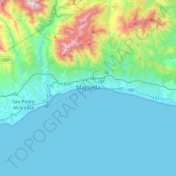
Name: Marbella topographic map, elevation, terrain.
Location: Marbella, Costa del Sol Occidental, Malaga, Andalusia, Spain (36.46001 -5.01467 36.55497 -4.73057)
Average elevation: 709 ft
Minimum elevation: -3 ft
Maximum elevation: 4,327 ft
Make a donation
Gear up for your next adventure:
As an Amazon Associate, this site earns from qualifying purchases at no extra cost to you.
Other topographic maps
Click on a map to view its topography, its elevation and its terrain.
Make a donation
Gear up for your next adventure:
As an Amazon Associate, this site earns from qualifying purchases at no extra cost to you.
Make a donation
Gear up for your next adventure:
As an Amazon Associate, this site earns from qualifying purchases at no extra cost to you.
Make a donation
Gear up for your next adventure:
As an Amazon Associate, this site earns from qualifying purchases at no extra cost to you.
Casares del Sol
Spain > Andalusia > Costa del Sol Occidental > Casares > Casares del Sol
Average elevation: 135 ft
Make a donation
Gear up for your next adventure:
As an Amazon Associate, this site earns from qualifying purchases at no extra cost to you.
Urbanizacion Playa Mijas
Spain > Andalusia > Costa del Sol Occidental > Urbanización Chaparral > Urbanizacion Playa Mijas
Average elevation: 89 ft