
Make a donation
Gear up for your next adventure:
As an Amazon Associate, this site earns from qualifying purchases at no extra cost to you.
Campo-Mijas topographic map
Click on the map to display elevation.
Make a donation
Gear up for your next adventure:
As an Amazon Associate, this site earns from qualifying purchases at no extra cost to you.
About this map
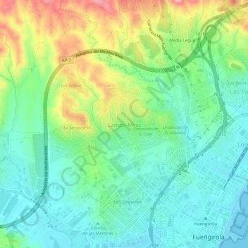
Name: Campo-Mijas topographic map, elevation, terrain.
Average elevation: 171 ft
Minimum elevation: -7 ft
Maximum elevation: 528 ft
Make a donation
Gear up for your next adventure:
As an Amazon Associate, this site earns from qualifying purchases at no extra cost to you.
Other topographic maps
Click on a map to view its topography, its elevation and its terrain.
Marbella
Spain > Andalusia > Costa del Sol Occidental
There are five geomorphological units: the Sierra Blanca, the Sierra Blanca piedmont (foothills), the lower hill country, the plains and the coastal dunes. The Sierra Blanca is most centrally located in the province, looming over the old village. This mountain range has three peaks: La Concha, located further…
Average elevation: 709 ft
Estepona
Spain > Andalusia > Costa del Sol Occidental
Estepona (Spanish pronunciation: [esteˈpona]) is a town and municipality in the comarca of the Costa del Sol, southern Spain. It is located in the province of Málaga, part of the autonomous community of Andalusia. Its district covers an area of 137 square kilometers in a fertile valley crossed by small…
Average elevation: 869 ft
Make a donation
Gear up for your next adventure:
As an Amazon Associate, this site earns from qualifying purchases at no extra cost to you.
Mijas
Spain > Andalusia > Costa del Sol Occidental
The climate changes gradually with increasing elevation in the mountains. Temperatures can drop to 10 °C (50 °F). In the peaks, over 600 m (2,000 ft) high, some ice may form in winter, while precipitation increases to almost 800 mm (32 in).
Average elevation: 561 ft
Marbella
Spain > Andalusia > Costa del Sol Occidental
There are five geomorphological areas in Marbella—the Sierra Blanca, the Sierra Blanca piedmont (foothills), the lower hill country, the plains and the coastal dunes. The Sierra Blanca is the most centrally-located in the province, peaking behind the old village. The mountain range has three notable…
Average elevation: 709 ft
Make a donation
Gear up for your next adventure:
As an Amazon Associate, this site earns from qualifying purchases at no extra cost to you.
Make a donation
Gear up for your next adventure:
As an Amazon Associate, this site earns from qualifying purchases at no extra cost to you.
Marbella
Spain > Andalusia > Costa del Sol Occidental
There are five geomorphological areas in Marbella—the Sierra Blanca, the Sierra Blanca piedmont (foothills), the lower hill country, the plains and the coastal dunes. The Sierra Blanca is the most centrally-located in the province, peaking behind the old village. The mountain range has three notable…
Average elevation: 709 ft
Estepona
Spain > Andalusia > Costa del Sol Occidental
Estepona (Spanish pronunciation: [esteˈpona]) is a town and municipality in the comarca of the Costa del Sol, southern Spain. It is located in the province of Málaga, part of the autonomous community of Andalusia. Its district covers an area of 137 square kilometers in a fertile valley crossed by small…
Average elevation: 869 ft
Make a donation
Gear up for your next adventure:
As an Amazon Associate, this site earns from qualifying purchases at no extra cost to you.
Mijas
Spain > Andalusia > Costa del Sol Occidental
The climate changes gradually with increasing elevation in the mountains. Temperatures can drop to 10 °C (50 °F). In the peaks, over 600 m (2,000 ft) high, some ice may form in winter, while precipitation increases to almost 800 mm (32 in).
Average elevation: 561 ft
Marbella
Spain > Andalusia > Costa del Sol Occidental
There are five geomorphological units: the Sierra Blanca, the Sierra Blanca piedmont (foothills), the lower hill country, the plains and the coastal dunes. The Sierra Blanca is most centrally located in the province, looming over the old village. This mountain range has three peaks: La Concha, located further…
Average elevation: 709 ft
Make a donation
Gear up for your next adventure:
As an Amazon Associate, this site earns from qualifying purchases at no extra cost to you.
Mijas
Spain > Andalusia > Costa del Sol Occidental
The climate changes gradually with increasing elevation in the mountains. Temperatures can drop to 10 °C (50 °F). In the peaks, over 600 m (2,000 ft) high, some ice may form in winter, while precipitation increases to almost 800 mm (32 in).
Average elevation: 561 ft
Make a donation
Gear up for your next adventure:
As an Amazon Associate, this site earns from qualifying purchases at no extra cost to you.
San Pedro de Alcántara
Spain > Andalusia > Costa del Sol Occidental > Marbella
Average elevation: 95 ft