Geolocate

Freeport topographic map

Click on the map to display elevation.

About this map

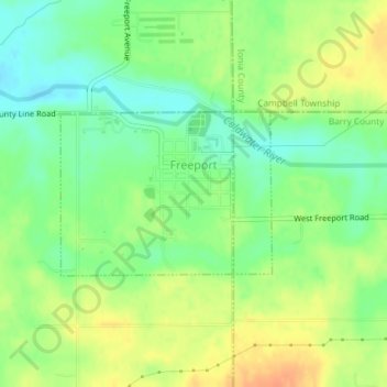
Name: Freeport topographic map, elevation, terrain.

Location: Freeport, Irving Township, Barry County, Michigan, United States (42.75837 -85.32599 42.76984 -85.30586)

Average elevation: 804 ft

Minimum elevation: 741 ft

Maximum elevation: 869 ft

Barry County trails, hiking, mountain biking, running and outdoor activities

Other topographic maps

Click on a map to view its topography, its elevation and its terrain.

Dowling

United States > Michigan > Barry County

Average elevation: 958 ft

Delton

United States > Michigan > Barry County

Average elevation: 938 ft

Assyria

United States > Michigan > Barry County > Assyria

Average elevation: 899 ft

Prairieville

United States > Michigan > Barry County > Prairieville

Average elevation: 968 ft

Hickory Corners

United States > Michigan > Barry County

Average elevation: 948 ft

Orangeville

United States > Michigan > Barry County

Average elevation: 781 ft

Gear up for your next adventure:

💧Water Purification System - Clean water on the trail with reliable purifiers
👟Men's Trail Runners - Lightweight footwear for fast-paced exploration and light hiking
🌎3D Topographic Globes - Raised relief globes for a tactile understanding of geography
🎒Trekking Poles - Sturdy poles for balance and stability on rough terrain
🧯Portable Fire Pit - Compact fire pit for camping spots

As an Amazon Associate, this site earns from qualifying purchases at no extra cost to you.