
Make a donation
Gear up for your next adventure:
As an Amazon Associate, this site earns from qualifying purchases at no extra cost to you.
Catalina Foothills topographic map
Click on the map to display elevation.
Make a donation
Gear up for your next adventure:
As an Amazon Associate, this site earns from qualifying purchases at no extra cost to you.
About this map
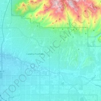
Name: Catalina Foothills topographic map, elevation, terrain.
Average elevation: 3,114 ft
Minimum elevation: 2,300 ft
Maximum elevation: 7,362 ft
Pima County trails, hiking, mountain biking, running and outdoor activities
Make a donation
Gear up for your next adventure:
As an Amazon Associate, this site earns from qualifying purchases at no extra cost to you.
Other topographic maps
Click on a map to view its topography, its elevation and its terrain.
Tucson
United States > Arizona > Pima County > Tucson
The city's elevation is 2,643 ft (806 m) above sea level (as measured at the Tucson International Airport). Tucson is on an alluvial plain in the Sonoran Desert, surrounded by five minor ranges of mountains: the Santa Catalina Mountains and the Tortolita Mountains to the north, the Santa Rita Mountains to the…
Average elevation: 2,743 ft
Make a donation
Gear up for your next adventure:
As an Amazon Associate, this site earns from qualifying purchases at no extra cost to you.