Geolocate

Linganore topographic map

Click on the map to display elevation.

About this map

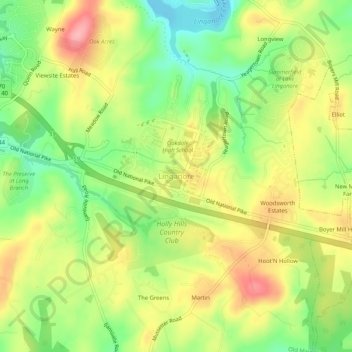
Name: Linganore topographic map, elevation, terrain.

Location: Linganore, Frederick County, Maryland, 21774, United States (39.37170 -77.33162 39.41170 -77.29162)

Average elevation: 492 ft

Minimum elevation: 299 ft

Maximum elevation: 696 ft

Frederick County trails, hiking, mountain biking, running and outdoor activities

Other topographic maps

Click on a map to view its topography, its elevation and its terrain.

Woodsboro

United States > Maryland > Frederick County

Average elevation: 404 ft

New Market

United States > Maryland > Frederick County

Average elevation: 499 ft

Clover Hill

United States > Maryland > Frederick County

Average elevation: 364 ft

Burkittsville

United States > Maryland > Frederick County

Average elevation: 610 ft

Rosemont

United States > Maryland > Frederick County

Average elevation: 449 ft

Green Valley

United States > Maryland > Frederick County

Average elevation: 505 ft

Flat Run

United States > Maryland > Frederick County > Emmitsburg

Average elevation: 453 ft

Gear up for your next adventure:

GPS Sports Watch - GPS watch for running, hiking and training
🦺Reflective Outdoor Gear - Safety gear for low‑light conditions
🧭Outdoor Navigation Book - Learn advanced navigation skills
🏫Relief Map Kits - Hands-on tools for teaching landforms and elevation
Solar GPS Watches - Advanced multisport watches with built-in topographic maps

As an Amazon Associate, this site earns from qualifying purchases at no extra cost to you.