
Thank you for supporting this site ❤️
Make a donation
Make a donation
Gear up for your next adventure:
As an Amazon Associate, this site earns from qualifying purchases at no extra cost to you.
Lake Wyangan topographic map
Click on the map to display elevation.
Thank you for supporting this site ❤️
Make a donation
Make a donation
Gear up for your next adventure:
As an Amazon Associate, this site earns from qualifying purchases at no extra cost to you.
About this map
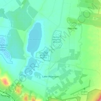
Name: Lake Wyangan topographic map, elevation, terrain.
Average elevation: 400 ft
Minimum elevation: 335 ft
Maximum elevation: 627 ft
Thank you for supporting this site ❤️
Make a donation
Make a donation
Gear up for your next adventure:
As an Amazon Associate, this site earns from qualifying purchases at no extra cost to you.
Other topographic maps
Click on a map to view its topography, its elevation and its terrain.
Sir Dudley de Chair Lookout
Australia > New South Wales > Griffith City Council > Griffith
Average elevation: 486 ft
Borland Leckie Park
Australia > New South Wales > Griffith City Council > Griffith
Average elevation: 413 ft