
Banke National Park topographic map
Interactive map
Click on the map to display elevation.
About this map
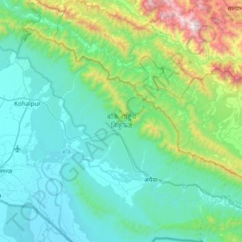
Name: Banke National Park topographic map, elevation, terrain.
Location: Banke National Park, Banke, Lumbini Province, Nepal (27.97608 81.66036 28.33815 82.19405)
Average elevation: 1,627 ft
Minimum elevation: 423 ft
Maximum elevation: 7,848 ft
Other topographic maps
Click on a map to view its topography, its elevation and its terrain.
Nepalgunj
Nepal > Lumbini Province > Banke
Nepalgunj, NSMC-24 | Khas Karkando, Banke, Lumbini Province, 22010, Nepal
Average elevation: 492 ft
Kohalpur
Nepal > Lumbini Province > Banke
Kohalpur, Banke, Lumbini Province, 21904, Nepal
Average elevation: 846 ft
Khajura
Nepal > Lumbini Province > Banke
Khajura, Banke, Lumbini Province, Nepal
Average elevation: 486 ft