
Thank you for supporting this site ❤️
Make a donation
Make a donation
Gear up for your next adventure:
As an Amazon Associate, this site earns from qualifying purchases at no extra cost to you.
Oberzollhaus topographic map
Click on the map to display elevation.
Thank you for supporting this site ❤️
Make a donation
Make a donation
Gear up for your next adventure:
As an Amazon Associate, this site earns from qualifying purchases at no extra cost to you.
About this map
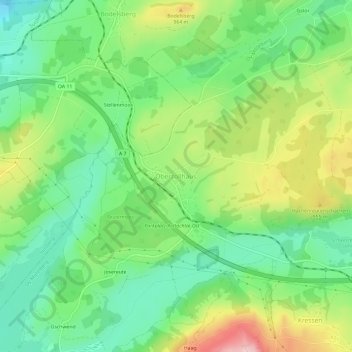
Name: Oberzollhaus topographic map, elevation, terrain.
Average elevation: 2,943 ft
Minimum elevation: 2,677 ft
Maximum elevation: 3,461 ft
Thank you for supporting this site ❤️
Make a donation
Make a donation
Gear up for your next adventure:
As an Amazon Associate, this site earns from qualifying purchases at no extra cost to you.
Other topographic maps
Click on a map to view its topography, its elevation and its terrain.
Grüntensee
Deutschland > Bayern > Landkreis Oberallgäu > Oy-Mittelberg > Faistenoy
Average elevation: 3,009 ft
87466
Deutschland > Bayern > Landkreis Oberallgäu > Oy-Mittelberg > Kressen > Fischersäge
Average elevation: 3,018 ft