
Hyon topographic map
Interactive map
Click on the map to display elevation.
About this map
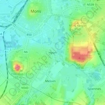
Name: Hyon topographic map, elevation, terrain.
Location: Hyon, Bergen, Henegouwen, Wallonië, 7022, België (50.41924 3.94194 50.45924 3.98194)
Average elevation: 157 ft
Minimum elevation: 79 ft
Maximum elevation: 394 ft
Other topographic maps
Click on a map to view its topography, its elevation and its terrain.
Havré
België > Henegouwen > Bergen > Bergen
Havré, Bergen, Henegouwen, Wallonië, 7021, België
Average elevation: 200 ft