
Make a donation
Gear up for your next adventure:
As an Amazon Associate, this site earns from qualifying purchases at no extra cost to you.
Altura topographic map
Click on the map to display elevation.
Make a donation
Gear up for your next adventure:
As an Amazon Associate, this site earns from qualifying purchases at no extra cost to you.
About this map
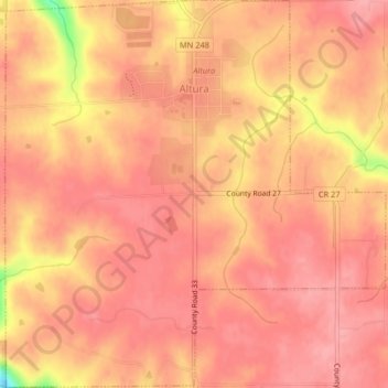
Name: Altura topographic map, elevation, terrain.
Location: Altura, Winona County, Minnesota, United States (44.04902 -91.95952 44.07833 -91.91942)
Average elevation: 1,165 ft
Minimum elevation: 906 ft
Maximum elevation: 1,230 ft
Winona County trails, hiking, mountain biking, running and outdoor activities
Make a donation
Gear up for your next adventure:
As an Amazon Associate, this site earns from qualifying purchases at no extra cost to you.
Other topographic maps
Click on a map to view its topography, its elevation and its terrain.
Country Valley Mobile Home Park
United States > Minnesota > Winona County > Goodview
Average elevation: 758 ft