
Make a donation
Gear up for your next adventure:
As an Amazon Associate, this site earns from qualifying purchases at no extra cost to you.
Stevensville topographic map
Click on the map to display elevation.
Make a donation
Gear up for your next adventure:
As an Amazon Associate, this site earns from qualifying purchases at no extra cost to you.
About this map
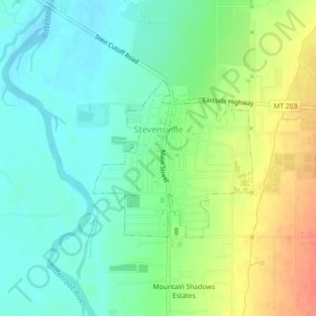
Name: Stevensville topographic map, elevation, terrain.
Location: Stevensville, Ravalli County, Montana, United States (46.50117 -114.10248 46.51462 -114.08275)
Average elevation: 3,323 ft
Minimum elevation: 3,264 ft
Maximum elevation: 3,422 ft
Ravalli County trails, hiking, mountain biking, running and outdoor activities
Make a donation
Gear up for your next adventure:
As an Amazon Associate, this site earns from qualifying purchases at no extra cost to you.
Other topographic maps
Click on a map to view its topography, its elevation and its terrain.
Bitterroot Range
United States > Montana > Ravalli County
The site of Brower's Spring is at about 8,800 feet (2,680 m) in elevation in the Centennials. The site is now commemorated by a rock cairn at the source of Hellroaring Creek, which flows into the Red Rock River and then into Clark canyon reservoir, where it joins the Beaverhead River and then the Big Hole…
Average elevation: 6,929 ft