
Make a donation
Gear up for your next adventure:
As an Amazon Associate, this site earns from qualifying purchases at no extra cost to you.
Parque Linear Rachel de Queiroz topographic map
Click on the map to display elevation.
Make a donation
Gear up for your next adventure:
As an Amazon Associate, this site earns from qualifying purchases at no extra cost to you.
About this map
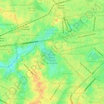
Name: Parque Linear Rachel de Queiroz topographic map, elevation, terrain.
Average elevation: 75 ft
Minimum elevation: 13 ft
Maximum elevation: 121 ft
Make a donation
Gear up for your next adventure:
As an Amazon Associate, this site earns from qualifying purchases at no extra cost to you.
Other topographic maps
Click on a map to view its topography, its elevation and its terrain.
Fortaleza
Está localizada no litoral Atlântico, a uma altitude média de dezesseis metros, com 34 km de praias. Fortaleza possui 313,140 km² de área e 2 643 247 habitantes estimados em 2018, além da maior densidade demográfica entre as capitais do país, com 8 390,76 hab/km². É a maior cidade do Ceará em…
Average elevation: 43 ft
Make a donation
Gear up for your next adventure:
As an Amazon Associate, this site earns from qualifying purchases at no extra cost to you.