
Burg Schadeck topographic map
Interactive map
Click on the map to display elevation.
About this map
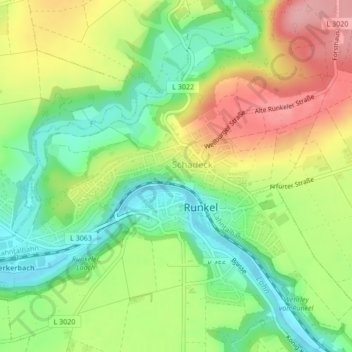
Name: Burg Schadeck topographic map, elevation, terrain.
Average elevation: 554 ft
Minimum elevation: 371 ft
Maximum elevation: 787 ft
Other topographic maps
Click on a map to view its topography, its elevation and its terrain.
Arfurt
Deutschland > Hessen > Runkel > Arfurt
Arfurt, Runkel, Landkreis Limburg-Weilburg, Hessen, 65594, Deutschland
Average elevation: 617 ft
Hofen
Deutschland > Hessen > Runkel > Hofen
Hofen, Runkel, Landkreis Limburg-Weilburg, Hessen, 65594, Deutschland
Average elevation: 630 ft