
Make a donation
Gear up for your next adventure:
As an Amazon Associate, this site earns from qualifying purchases at no extra cost to you.
Albé topographic map
Click on the map to display elevation.
Make a donation
Gear up for your next adventure:
As an Amazon Associate, this site earns from qualifying purchases at no extra cost to you.
Albé
It is located 2 km (1.2 mi) northeast of Villé, on the left bank of the river Giessen close to the valley of Erlenbach, from which it derives its name. To the North and West it is bounded by mountains leading to the communes of Hohwald and Breitenbach. To the East is the peak of Ungersberg. Numerous streams flow from this mounting and the buttresses of the Champ du Feu to the north, which merge to form the brook of the Erlenberg. This river formerly flowed down the main street of the village, but has now been covered. The village is at approximately 300 m (980 ft) altitude.
Make a donation
Gear up for your next adventure:
As an Amazon Associate, this site earns from qualifying purchases at no extra cost to you.
About this map
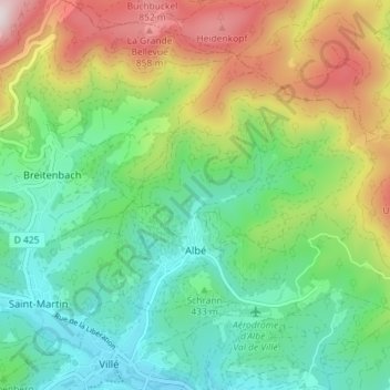
Name: Albé topographic map, elevation, terrain.
Average elevation: 1,624 ft
Minimum elevation: 840 ft
Maximum elevation: 3,143 ft
Make a donation
Gear up for your next adventure:
As an Amazon Associate, this site earns from qualifying purchases at no extra cost to you.
Other topographic maps
Click on a map to view its topography, its elevation and its terrain.