Geolocate

Timbercombe topographic map

Click on the map to display elevation.

About this map

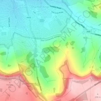
Name: Timbercombe topographic map, elevation, terrain.

Location: Timbercombe, Beeches, Charlton Kings, Cheltenham, Gloucestershire, England, United Kingdom (51.87117 -2.04979 51.87336 -2.04189)

Average elevation: 522 ft

Minimum elevation: 253 ft

Maximum elevation: 971 ft

Other topographic maps

Click on a map to view its topography, its elevation and its terrain.

Ham

United Kingdom > England > Gloucestershire > Cheltenham > Charlton Kings

Average elevation: 459 ft

Ham

United Kingdom > England > Gloucestershire > Cheltenham > Charlton Kings

Average elevation: 459 ft

Gear up for your next adventure:

🧣Hiking Neck Gaiter - Multi‑use neck protection for outdoor weather
🧤Tactile Hiking Gloves - Keep hands warm while operating GPS and smartphone screens
❄️Traction Cleats - Prevent slips on icy trails during winter hikes
🕶️Glacier Sunglasses - Side shields to protect eyes from high-altitude snow glare
🧥Waterproof Jacket for Hiking - Breathable and rugged rain jacket for outdoor excursions

As an Amazon Associate, this site earns from qualifying purchases at no extra cost to you.