
Make a donation
Gear up for your next adventure:
As an Amazon Associate, this site earns from qualifying purchases at no extra cost to you.
Marxheim topographic map
Click on the map to display elevation.
Make a donation
Gear up for your next adventure:
As an Amazon Associate, this site earns from qualifying purchases at no extra cost to you.
About this map
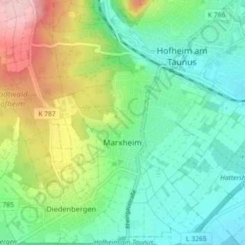
Name: Marxheim topographic map, elevation, terrain.
Average elevation: 587 ft
Minimum elevation: 361 ft
Maximum elevation: 1,086 ft
Make a donation
Gear up for your next adventure:
As an Amazon Associate, this site earns from qualifying purchases at no extra cost to you.
Other topographic maps
Click on a map to view its topography, its elevation and its terrain.
Bad Soden am Taunus
Deutschland > Hessen > Main-Taunus-Kreis
Bad Soden am Taunus liegt am Südhang des Taunus, 15 Kilometer nordwestlich von Frankfurt am Main und 20 Kilometer nordöstlich von Wiesbaden. Die Gemarkungsfläche umfasst insgesamt 1247 Hektar. Hiervon sind 231 Hektar bewaldet. Auf den Stadtteil Bad Soden (Kernstadt) entfallen 479 Hektar, auf den Stadtteil…
Average elevation: 623 ft
Schwalbach am Taunus
Deutschland > Hessen > Main-Taunus-Kreis > Schwalbach > Schwalbach am Taunus
Average elevation: 564 ft
Sulzbach
Deutschland > Hessen > Main-Taunus-Kreis > Sulzbach (Taunus) > Sulzbach
Seit 1997 ist in Sulzbach die Höhenrettungsgruppe (HöRG) der Feuerwehr des Main-Taunus-Kreises stationiert. Ihre Aufgaben bestehen im Retten und Bergen von Verletzten aus Höhen und Tiefen, welche im Allgemeinen für eine gewöhnliche Feuerwehr nicht erreichbar sind. Um sich zu den Höhenrettern zählen zu…
Average elevation: 456 ft
Make a donation
Gear up for your next adventure:
As an Amazon Associate, this site earns from qualifying purchases at no extra cost to you.
Hattersheim
Deutschland > Hessen > Main-Taunus-Kreis > Hattersheim am Main > Hattersheim
Average elevation: 390 ft