
Novi Pazar topographic map
Click on the map to display elevation.
Novi Pazar
Novi Pazar is located in the valleys of the Jošanica, Raška, Deževska, and Ljudska rivers. It lies at an elevation of 496m, in the southeast Raška region. The city is surrounded by the Golija and Rogozna mountains, and the Pešter plateau lies to the west. The total area of the city administrative area is 742 km². It contains 100 settlements, mostly small and spread over hills and mountains surrounding the city. The largest village is Mur, with over 3000 residents.
About this map
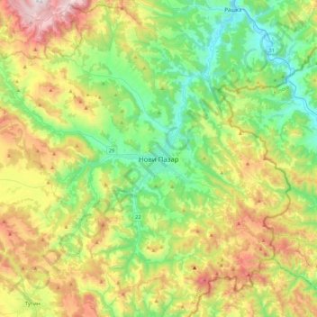
Name: Novi Pazar topographic map, elevation, terrain.
Average elevation: 2,867 ft
Minimum elevation: 1,312 ft
Maximum elevation: 5,843 ft