Geolocate

Maug River topographic map

Click on the map to display elevation.

About this map

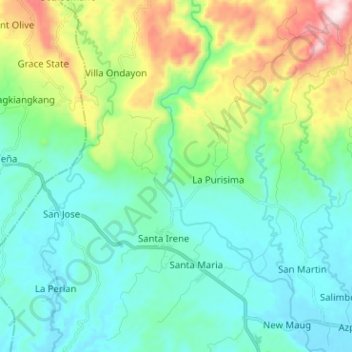
Name: Maug River topographic map, elevation, terrain.

Location: Maug River, Prosperidad, Agusan del Sur, Caraga, Philippines (8.62973 125.87663 8.75513 125.93081)

Average elevation: 725 ft

Minimum elevation: 148 ft

Maximum elevation: 2,546 ft

Other topographic maps

Click on a map to view its topography, its elevation and its terrain.

Patin-ay

Philippines > Agusan del Sur > Prosperidad

Average elevation: 125 ft

San Lorenzo

Philippines > Agusan del Sur > Prosperidad

Average elevation: 417 ft

Patin-ay

Philippines > Agusan del Sur > Prosperidad

Average elevation: 125 ft

Gear up for your next adventure:

🪑Ultralight Camp Chairs - Portable seating for resting after a long day of mapping
🩳Quick‑Dry Hiking Shorts - Comfortable and quick‑dry shorts for summer hiking
🌡️Handheld Weather Meters - Measure wind, temp, and pressure for safe mountain travel
📷Action Camera - Capture your outdoor adventures in HD
🧣Hiking Neck Gaiter - Multi‑use neck protection for outdoor weather

As an Amazon Associate, this site earns from qualifying purchases at no extra cost to you.