Geolocate

Basag topographic map

Click on the map to display elevation.

About this map

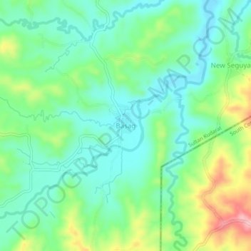
Name: Basag topographic map, elevation, terrain.

Location: Basag, Sultan Kudarat, Soccsksargen, Philippines (6.33483 124.38298 6.37483 124.42298)

Average elevation: 2,418 ft

Minimum elevation: 2,247 ft

Maximum elevation: 2,812 ft

Other topographic maps

Click on a map to view its topography, its elevation and its terrain.

Kabulnan River

Philippines > Sultan Kudarat

Average elevation: 1,939 ft

Columbio

Philippines > Sultan Kudarat

Average elevation: 879 ft

Lutayan

Philippines > Sultan Kudarat

Average elevation: 240 ft

Kapingkong River

Philippines > Sultan Kudarat > Sampao

Average elevation: 200 ft

Gear up for your next adventure:

🗺️Topographic Maps - Detailed topo maps for hiking, exploring and outdoor navigation
🔋Solar Power Banks - Keep your GPS and phone charged in remote wilderness areas
📡GPS Antenna Upgrade - Enhance GPS reception in remote terrain
🦶Hiking Gaiters - Keep debris and water out of your boots
📌Outdoor GPS Map App - Apps and devices for digital topographic navigation

As an Amazon Associate, this site earns from qualifying purchases at no extra cost to you.