Geolocate

River Falls topographic map

Click on the map to display elevation.

About this map

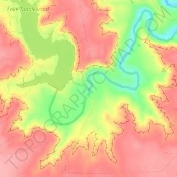
Name: River Falls topographic map, elevation, terrain.

Location: River Falls, Randall County, Texas, United States (35.03955 -101.76440 35.03965 -101.76430)

Average elevation: 3,448 ft

Minimum elevation: 3,219 ft

Maximum elevation: 3,576 ft

Randall County trails, hiking, mountain biking, running and outdoor activities

Other topographic maps

Click on a map to view its topography, its elevation and its terrain.

Canyon

United States > Texas > Randall County

Average elevation: 3,560 ft

Timbercreek Canyon

United States > Texas > Randall County

Average elevation: 3,530 ft

Buffalo Lake

United States > Texas > Randall County

Average elevation: 3,658 ft

Lake Tanglewood

United States > Texas > Randall County

Average elevation: 3,501 ft

Gear up for your next adventure:

🥄Camping Utensil Set - Lightweight utensils for outdoor meals
🔭Stargazing Telescopes - Perfect for camping in low-light pollution areas shown on maps
🗺️NatGeo Topo Maps - High-quality waterproof printed topographic maps of US Parks
📷Action Camera - Capture your outdoor adventures in HD
🎒Hydration Pack - Hands‑free water reservoir for long hikes

As an Amazon Associate, this site earns from qualifying purchases at no extra cost to you.