
Thank you for supporting this site ❤️
Make a donation
Make a donation
Gear up for your next adventure:
As an Amazon Associate, this site earns from qualifying purchases at no extra cost to you.
Bombeo topographic map
Click on the map to display elevation.
Thank you for supporting this site ❤️
Make a donation
Make a donation
Gear up for your next adventure:
As an Amazon Associate, this site earns from qualifying purchases at no extra cost to you.
About this map
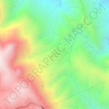
Name: Bombeo topographic map, elevation, terrain.
Location: Bombeo, Municipio Tapacarí, Tapacarí, Cochabamba, Bolivia (-17.64186 -66.45568 -17.63832 -66.45096)
Average elevation: 11,450 ft
Minimum elevation: 10,220 ft
Maximum elevation: 12,838 ft
Thank you for supporting this site ❤️
Make a donation
Make a donation
Gear up for your next adventure:
As an Amazon Associate, this site earns from qualifying purchases at no extra cost to you.
Other topographic maps
Click on a map to view its topography, its elevation and its terrain.