
Make a donation
Gear up for your next adventure:
As an Amazon Associate, this site earns from qualifying purchases at no extra cost to you.
Macerata topographic map
Click on the map to display elevation.
Make a donation
Gear up for your next adventure:
As an Amazon Associate, this site earns from qualifying purchases at no extra cost to you.
Macerata
Macerata heeft een van de oudste (1290) universiteiten van Italië. De stad telt diverse monumenten waaronder het openluchttheater Sferisterio uit 1819, geïnspireerd op de bouwwerken van Andrea Palladio. Het Piazza della Libertà is het hart van de stad. Hier staan onder andere de Universiteit, het theater, de 15de-eeuwse toren Torre Civica en de Loggia dei Mercanti. De drie andere belangrijkste plaatsen op het gebied van kunst zijn Tolentino, San Severino Marche en Recanati. De plaats Cingoli ligt op een hoogte van 600 meter en biedt uitzicht over de omgeving; het heeft de bijnaam Balkon van de Marken.
Make a donation
Gear up for your next adventure:
As an Amazon Associate, this site earns from qualifying purchases at no extra cost to you.
About this map
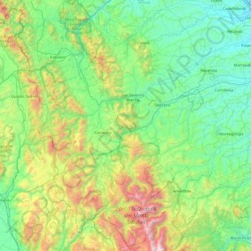
Name: Macerata topographic map, elevation, terrain.
Location: Macerata, Marken, Italië (42.83185 12.82965 43.47394 13.74358)
Average elevation: 1,844 ft
Minimum elevation: 13 ft
Maximum elevation: 7,992 ft
Make a donation
Gear up for your next adventure:
As an Amazon Associate, this site earns from qualifying purchases at no extra cost to you.
Other topographic maps
Click on a map to view its topography, its elevation and its terrain.
Make a donation
Gear up for your next adventure:
As an Amazon Associate, this site earns from qualifying purchases at no extra cost to you.
Make a donation
Gear up for your next adventure:
As an Amazon Associate, this site earns from qualifying purchases at no extra cost to you.
Make a donation
Gear up for your next adventure:
As an Amazon Associate, this site earns from qualifying purchases at no extra cost to you.