Geolocate

Dorking topographic map

Click on the map to display elevation.

About this map

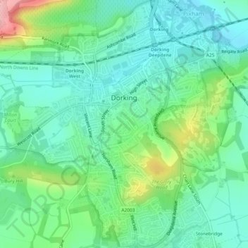
Name: Dorking topographic map, elevation, terrain.

Location: Dorking, Mole Valley, Surrey, England, United Kingdom (51.21505 -0.34847 51.24386 -0.32072)

Average elevation: 262 ft

Minimum elevation: 128 ft

Maximum elevation: 617 ft

Other topographic maps

Click on a map to view its topography, its elevation and its terrain.

Ashtead

United Kingdom > England > Surrey > Mole Valley

Average elevation: 246 ft

Clark's Green

United Kingdom > England > Surrey > Mole Valley > Capel

Average elevation: 279 ft

Broadmoor

United Kingdom > England > Surrey > Mole Valley

Average elevation: 574 ft

Westhumble

United Kingdom > England > Surrey > Mole Valley

Average elevation: 318 ft

Box Hill

United Kingdom > England > Surrey > Mole Valley > Pixham

The 15.8 km (9.8 mi) Box Hill Olympic circuit is generally cycled in an anticlockwise direction and begins to the south of the village of Mickleham with an ascent of the hill via the Zig Zag Road. From the National Trust Visitor Centre, the route turns eastwards, running along the escarpment and through the…

Average elevation: 344 ft

Leatherhead

United Kingdom > England > Surrey > Mole Valley

Average elevation: 266 ft

Pixham

United Kingdom > England > Surrey > Mole Valley

Average elevation: 299 ft

Abinger Bottom

United Kingdom > England > Surrey > Mole Valley > Abinger

Average elevation: 643 ft

Vale Farm

United Kingdom > England > Surrey > Mole Valley

Average elevation: 446 ft

Strood Green

United Kingdom > England > Surrey > Mole Valley > Brockham

Average elevation: 197 ft

Dorking

United Kingdom > England > Surrey > Mole Valley

Average elevation: 351 ft

Headley Heath

United Kingdom > England > Surrey > Mole Valley > Headley

Average elevation: 535 ft

Hookwood

United Kingdom > England > Surrey > Mole Valley

Average elevation: 197 ft

Leith Hill

United Kingdom > England > Surrey > Mole Valley

Average elevation: 643 ft

Great Bookham

United Kingdom > England > Surrey > Mole Valley

Average elevation: 262 ft

Box Hill Village

United Kingdom > England > Surrey > Mole Valley

Average elevation: 410 ft

Westcott

United Kingdom > England > Surrey > Mole Valley

Average elevation: 381 ft

Okewood Hill

United Kingdom > England > Surrey > Mole Valley

Average elevation: 220 ft

Abinger Hammer

United Kingdom > England > Surrey > Mole Valley

Average elevation: 456 ft

Beare Green

United Kingdom > England > Surrey > Mole Valley

Average elevation: 351 ft

Capel

United Kingdom > England > Surrey > Mole Valley

Average elevation: 299 ft

Givons Grove

United Kingdom > England > Surrey > Mole Valley

Average elevation: 285 ft

Lodge Hill

United Kingdom > England > Surrey > Mole Valley

Average elevation: 361 ft

Westhumble

United Kingdom > England > Surrey > Mole Valley

Average elevation: 318 ft

Box Hill

United Kingdom > England > Surrey > Mole Valley > Pixham

The 15.8 km (9.8 mi) Box Hill Olympic circuit is generally cycled in an anticlockwise direction and begins to the south of the village of Mickleham with an ascent of the hill via the Zig Zag Road. From the National Trust Visitor Centre, the route turns eastwards, running along the escarpment and through the…

Average elevation: 344 ft

Dorking

United Kingdom > England > Surrey > Mole Valley

Average elevation: 351 ft

Dorking

United Kingdom > England > Surrey > Mole Valley

Average elevation: 351 ft

Leatherhead

United Kingdom > England > Surrey > Mole Valley

Average elevation: 266 ft

Ashtead

United Kingdom > England > Surrey > Mole Valley

Average elevation: 246 ft

Dorking

United Kingdom > England > Surrey > Mole Valley

Average elevation: 351 ft

Gear up for your next adventure:

🎒Hydration Pack - Hands‑free water reservoir for long hikes
🗺️NatGeo Topo Maps - High-quality waterproof printed topographic maps of US Parks
🧭Orienteering Set - Complete compass and map reading kit
📶Vehicle Signal Boosters - Improve reception in rural areas while driving to trailheads
🌧️Backpack Rain Cover - Keep gear dry in wet weather

As an Amazon Associate, this site earns from qualifying purchases at no extra cost to you.