
Thank you for supporting this site ❤️
Make a donation
Make a donation
Gear up for your next adventure:
As an Amazon Associate, this site earns from qualifying purchases at no extra cost to you.
Chatrat topographic map
Click on the map to display elevation.
Thank you for supporting this site ❤️
Make a donation
Make a donation
Gear up for your next adventure:
As an Amazon Associate, this site earns from qualifying purchases at no extra cost to you.
About this map
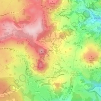
Name: Chatrat topographic map, elevation, terrain.
Average elevation: 2,976 ft
Minimum elevation: 2,513 ft
Maximum elevation: 3,356 ft
Thank you for supporting this site ❤️
Make a donation
Make a donation
Gear up for your next adventure:
As an Amazon Associate, this site earns from qualifying purchases at no extra cost to you.
Other topographic maps
Click on a map to view its topography, its elevation and its terrain.
63122
France > Auvergne-Rhône-Alpes > Puy-de-Dôme > Saint-Genès-Champanelle > Chatrat
Average elevation: 2,743 ft