
Thank you for supporting this site ❤️
Make a donation
Make a donation
Gear up for your next adventure:
As an Amazon Associate, this site earns from qualifying purchases at no extra cost to you.
Borgata topographic map
Click on the map to display elevation.
Thank you for supporting this site ❤️
Make a donation
Make a donation
Gear up for your next adventure:
As an Amazon Associate, this site earns from qualifying purchases at no extra cost to you.
About this map
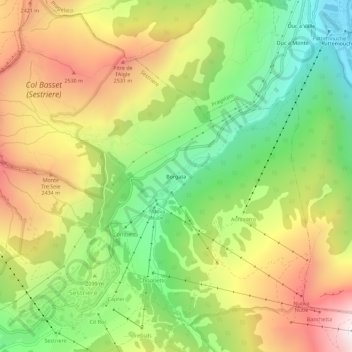
Name: Borgata topographic map, elevation, terrain.
Location: Borgata, Sestrières, Turin, Piémont, 10058, Italie (44.95165 6.87363 44.99165 6.91363)
Average elevation: 7,005 ft
Minimum elevation: 5,171 ft
Maximum elevation: 9,199 ft
Thank you for supporting this site ❤️
Make a donation
Make a donation
Gear up for your next adventure:
As an Amazon Associate, this site earns from qualifying purchases at no extra cost to you.