
Make a donation
Gear up for your next adventure:
As an Amazon Associate, this site earns from qualifying purchases at no extra cost to you.
Beaujoire - Halvèque topographic map
Click on the map to display elevation.
Make a donation
Gear up for your next adventure:
As an Amazon Associate, this site earns from qualifying purchases at no extra cost to you.
About this map
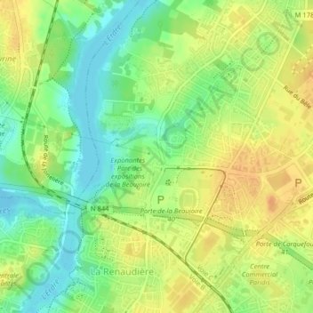
Name: Beaujoire - Halvèque topographic map, elevation, terrain.
Average elevation: 72 ft
Minimum elevation: 13 ft
Maximum elevation: 118 ft
Make a donation
Gear up for your next adventure:
As an Amazon Associate, this site earns from qualifying purchases at no extra cost to you.
Other topographic maps
Click on a map to view its topography, its elevation and its terrain.
Parc du Grand Blottereau
France > Pays de la Loire > Loire-Atlantique > Nantes
Average elevation: 33 ft
Parc floral de la Beaujoire - La Roseraie
France > Pays de la Loire > Loire-Atlantique > Nantes
Average elevation: 69 ft
Parc de Bottière-Chenaie
France > Pays de la Loire > Loire-Atlantique > Nantes
Average elevation: 66 ft
Make a donation
Gear up for your next adventure:
As an Amazon Associate, this site earns from qualifying purchases at no extra cost to you.
Parc naturel de Beaulieu
France > Pays de la Loire > Loire-Atlantique > Nantes
Average elevation: 33 ft