Geolocate
👉 Easily get elevation data in JSON, GeoTIFF and KML formats using Elevation API
Thank you for supporting this site ❤️
Make a donation

Bagacay topographic map

Click on the map to display elevation.

About this map

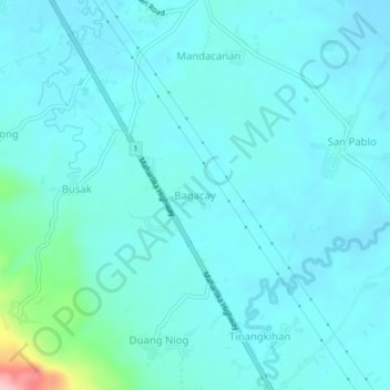
Name: Bagacay topographic map, elevation, terrain.

Location: Bagacay, Camarines Sur, Bicol Region, 4416, Philippines (13.62523 123.00739 13.66523 123.04739)

Average elevation: 92 ft

Minimum elevation: 13 ft

Maximum elevation: 650 ft

Gear up for your next adventure:

🧯Emergency Survival Kit - All‑in‑one survival essentials for the backcountry
🔦Compact Flashlight - Reliable flashlight for emergencies
🦶Carbon Trekking Poles - Reduce knee impact on steep descents with ultra-light poles
🥾Men's Hiking Boots - Durable, waterproof footwear for rugged terrain and steep inclines
🥇GPS Hiking Watch - Multi‑sport GPS watch with navigation and trail tracking

As an Amazon Associate, this site earns from qualifying purchases at no extra cost to you.