Geolocate

Al Qayyim topographic map

Click on the map to display elevation.

About this map

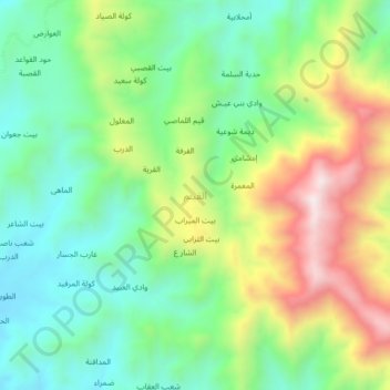
Name: Al Qayyim topographic map, elevation, terrain.

Location: Al Qayyim, Kushar District, Hajjah Governorate, Yemen (16.13549 43.44305 16.17549 43.48305)

Average elevation: 4,859 ft

Minimum elevation: 4,052 ft

Maximum elevation: 6,266 ft

Other topographic maps

Click on a map to view its topography, its elevation and its terrain.

Mustaba District

Yemen > Hajjah Governorate

Average elevation: 1,145 ft

Al Jamimah District

Yemen > Hajjah Governorate

Average elevation: 4,065 ft

Kushar District

Yemen > Hajjah Governorate

Average elevation: 3,763 ft

Al Mahabishah District

Yemen > Hajjah Governorate

Average elevation: 3,983 ft

Ash Shahil District

Yemen > Hajjah Governorate

Average elevation: 3,307 ft

Bakil Al Mir District

Yemen > Hajjah Governorate

Average elevation: 2,310 ft

Gear up for your next adventure:

🥾Men's Hiking Boots - Durable, waterproof footwear for rugged terrain and steep inclines
🦺Reflective Outdoor Gear - Safety gear for low‑light conditions
🗃️Trail First Aid Kit - Essential kit for outdoor injuries and emergencies
🔦LED Headlamp - Bright and durable LED headlamp for night navigation
❄️Traction Cleats - Prevent slips on icy trails during winter hikes

As an Amazon Associate, this site earns from qualifying purchases at no extra cost to you.