
Make a donation
Gear up for your next adventure:
As an Amazon Associate, this site earns from qualifying purchases at no extra cost to you.
Tianyuan topographic map
Click on the map to display elevation.
Make a donation
Gear up for your next adventure:
As an Amazon Associate, this site earns from qualifying purchases at no extra cost to you.
About this map
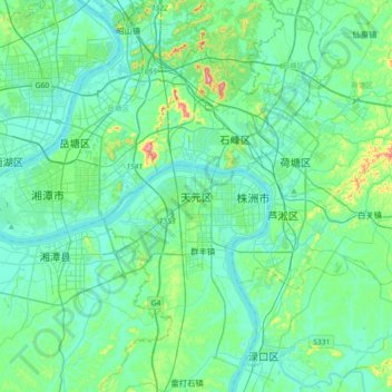
Name: Tianyuan topographic map, elevation, terrain.
Location: Tianyuan, Zhuzhou, Hunan, 412007, China (27.67106 112.91580 27.99106 113.23580)
Average elevation: 213 ft
Minimum elevation: 69 ft
Maximum elevation: 991 ft
Make a donation
Gear up for your next adventure:
As an Amazon Associate, this site earns from qualifying purchases at no extra cost to you.
Other topographic maps
Click on a map to view its topography, its elevation and its terrain.
Make a donation
Gear up for your next adventure:
As an Amazon Associate, this site earns from qualifying purchases at no extra cost to you.
Changsha
Auf der offiziellen Website der Stadt hieß es 2012, 800 Hochhäuser seien in den Jahren davor errichtet worden und 200 seien im Bau.[2][3] Zum Stand 2021 wurden für Changsha als Zahlen von Wolkenkratzern, d. h. Häuser ab einer Höhe von 150 m, 49 fertiggestellte und 10 im Bau angegeben.[4] Der höchste, der…
Average elevation: 591 ft