
Make a donation
Gear up for your next adventure:
As an Amazon Associate, this site earns from qualifying purchases at no extra cost to you.
Besenfeld topographic map
Click on the map to display elevation.
Make a donation
Gear up for your next adventure:
As an Amazon Associate, this site earns from qualifying purchases at no extra cost to you.
About this map
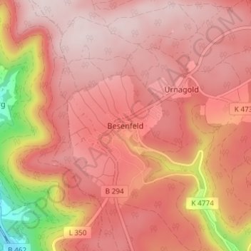
Name: Besenfeld topographic map, elevation, terrain.
Average elevation: 2,556 ft
Minimum elevation: 1,572 ft
Maximum elevation: 2,930 ft
Make a donation
Gear up for your next adventure:
As an Amazon Associate, this site earns from qualifying purchases at no extra cost to you.
Other topographic maps
Click on a map to view its topography, its elevation and its terrain.
Peterzell
Germany > Baden-Württemberg > Landkreis Freudenstadt > Alpirsbach
The township (Stadt) covers an area of 64.55 square kilometers (24.92 mi2) of the Freudenstadt district, within the state of Baden-Württemberg and the Federal Republic of Germany. Alpirsbach is physically located in the upper Kinzig valley, in the Central Black Forest, but also in the Upper Gäu (de) at the…
Average elevation: 2,096 ft
Make a donation
Gear up for your next adventure:
As an Amazon Associate, this site earns from qualifying purchases at no extra cost to you.
Friedrichsturm
Germany > Baden-Württemberg > Landkreis Freudenstadt > Freudenstadt
Average elevation: 2,470 ft
Dietersweiler
Germany > Baden-Württemberg > Landkreis Freudenstadt > Freudenstadt
Average elevation: 2,087 ft
Make a donation
Gear up for your next adventure:
As an Amazon Associate, this site earns from qualifying purchases at no extra cost to you.