Geolocate

Julian topographic map

Click on the map to display elevation.

About this map

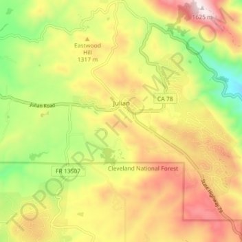
Name: Julian topographic map, elevation, terrain.

Location: Julian, San Diego County, California, 92038, United States (33.04449 -116.62251 33.10344 -116.55164)

Average elevation: 4,183 ft

Minimum elevation: 3,041 ft

Maximum elevation: 5,335 ft

California trails, hiking, mountain biking, running and outdoor activities

Gear up for your next adventure:

📶Vehicle Signal Boosters - Improve reception in rural areas while driving to trailheads
🧤Hiking Gloves - Protective gloves for rugged trails
🎒Trekking Poles - Sturdy poles for balance and stability on rough terrain
👟Trail Running Shoes - Lightweight shoes for trail runners
📻Weather Alert Radios - Stay informed of storm risks while off-the-grid

As an Amazon Associate, this site earns from qualifying purchases at no extra cost to you.