Geolocate

Midway topographic map

Click on the map to display elevation.

About this map

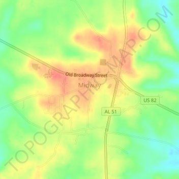
Name: Midway topographic map, elevation, terrain.

Location: Midway, Bullock County, Alabama, United States (32.06545 -85.52950 32.08729 -85.51138)

Average elevation: 492 ft

Minimum elevation: 400 ft

Maximum elevation: 574 ft

Alabama trails, hiking, mountain biking, running and outdoor activities

Gear up for your next adventure:

🔭Stargazing Telescopes - Perfect for camping in low-light pollution areas shown on maps
🔦Powerful Headlamps - Ultra-bright hands-free lighting for night navigation
🌡️Handheld Weather Meters - Measure wind, temp, and pressure for safe mountain travel
👟Trail Running Shoes - Lightweight shoes for trail runners
🔪Outdoor Multitools - Essential survival tools for gear repair and field use

As an Amazon Associate, this site earns from qualifying purchases at no extra cost to you.