Geolocate

Licking topographic map

Click on the map to display elevation.

About this map

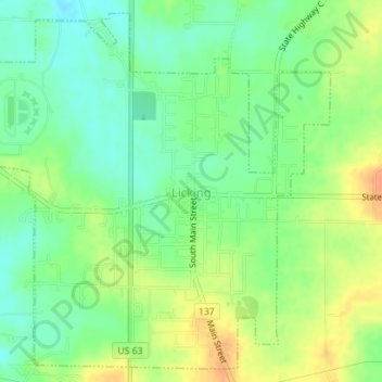
Name: Licking topographic map, elevation, terrain.

Location: Licking, Texas County, Missouri, 65542, United States (37.48655 -91.87939 37.51258 -91.84426)

Average elevation: 1,273 ft

Minimum elevation: 1,217 ft

Maximum elevation: 1,342 ft

Texas County trails, hiking, mountain biking, running and outdoor activities

Other topographic maps

Click on a map to view its topography, its elevation and its terrain.

Roby

United States > Missouri > Texas County

Average elevation: 1,322 ft

Eunice

United States > Missouri > Texas County

Average elevation: 1,293 ft

Ellsworth

United States > Missouri > Texas County

Average elevation: 1,125 ft

Pleasant Ridge

United States > Missouri > Texas County > Upton

Average elevation: 1,319 ft

Lead Hill

United States > Missouri > Texas County

Average elevation: 1,430 ft

Bucyrus

United States > Missouri > Texas County

Average elevation: 1,155 ft

Gear up for your next adventure:

🎒Outdoor Daypacks - Lightweight backpacks designed for carrying maps and essential gear
🔭Compact Binoculars - HD vision for scouting terrain and identifying distant landmarks
🔥Camping Stove - Portable stove for camping and backcountry cooking
🥾Men's Hiking Boots - Durable, waterproof footwear for rugged terrain and steep inclines
🎒Gear Packing Cubes - Organize your backpack efficiently

As an Amazon Associate, this site earns from qualifying purchases at no extra cost to you.