Anchorage topographic map
Click on the map to display elevation.
About this map

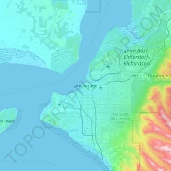
Name: Anchorage topographic map, elevation, terrain.
Location: Anchorage, Alaska, 99501, United States (61.05631 -150.05485 61.37631 -149.73485)
Average elevation: 407 ft
Minimum elevation: 0 ft
Maximum elevation: 5,108 ft
Other topographic maps
Click on a map to view its topography, its elevation and its terrain.

Chugach Meadows
United States > Alaska > Anchorage > Anchorage
Chugach Meadows, Anchorage, Alaska, United States
Average elevation: 151 ft

Chugiak
United States > Alaska > Anchorage
Chugiak, Anchorage, Alaska, United States
Average elevation: 968 ft

South Yuyanq’ Ch’ex
United States > Alaska > Anchorage
South Yuyanq’ Ch’ex, Anchorage, Alaska, United States
Average elevation: 3,514 ft

Alyeska
United States > Alaska > Anchorage > Girdwood
Alyeska, Girdwood, Anchorage, Alaska, 99523, United States
Average elevation: 840 ft

Knik Arm
United States > Alaska > Anchorage
Knik Arm, Anchorage, Alaska, United States
Average elevation: 236 ft

Powder Ridge
United States > Alaska > Anchorage
Powder Ridge, Anchorage, Alaska, United States
Average elevation: 292 ft

Girdwood
United States > Alaska > Anchorage
Girdwood, Anchorage, Alaska, 99587, United States
Average elevation: 594 ft