
Jay topographic map
Click on the map to display elevation.
About this map
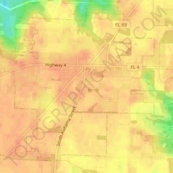
Name: Jay topographic map, elevation, terrain.
Location: Jay, Santa Rosa County, Florida, United States (30.93807 -87.16690 30.96122 -87.13870)
Average elevation: 259 ft
Minimum elevation: 154 ft
Maximum elevation: 285 ft
Santa Rosa County trails, hiking, mountain biking, running and outdoor activities
Other topographic maps
Click on a map to view its topography, its elevation and its terrain.
Navarre
United States > Florida > Santa Rosa County
Navarre is located at 30°24′04″N 86°51′47″W / 30.401°N 86.863°W / 30.401; -86.863Coordinates: 30°24′04″N 86°51′47″W / 30.401°N 86.863°W / 30.401; -86.863. It is located within a portion of the Florida Panhandle observing the Central Time Zone. Elevation is at an average of 10 feet (3.0 m).
Average elevation: 13 ft
Navarre
United States > Florida > Santa Rosa County
As a low-elevation community near the Gulf of Mexico, Navarre is often threatened by hurricanes. Significant damage was incurred as a result of hurricanes Erin and Opal in 1995, Georges in 1998, Ivan in 2004, Dennis in 2005 and Sally in 2020. Many homes and businesses immediately along Santa Rosa Sound…
Average elevation: 13 ft
Navarre
United States > Florida > Santa Rosa County
Navarre is located at 30°24′04″N 86°51′47″W / 30.401°N 86.863°W / 30.401; -86.863Coordinates: 30°24′04″N 86°51′47″W / 30.401°N 86.863°W / 30.401; -86.863. It is located within a portion of the Florida Panhandle observing the Central Time Zone. Elevation is at an average of 10 feet (3.0 m).
Average elevation: 13 ft