
Thank you for supporting this site ❤️
Make a donation
Make a donation
Gear up for your next adventure:
As an Amazon Associate, this site earns from qualifying purchases at no extra cost to you.
Borrelho topographic map
Click on the map to display elevation.
Thank you for supporting this site ❤️
Make a donation
Make a donation
Gear up for your next adventure:
As an Amazon Associate, this site earns from qualifying purchases at no extra cost to you.
About this map
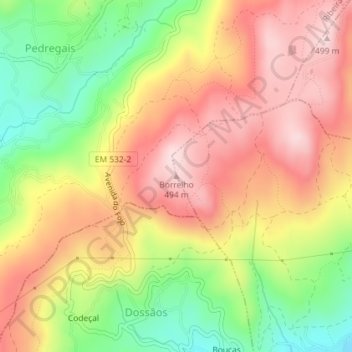
Name: Borrelho topographic map, elevation, terrain.
Location: Borrelho, Vila Verde, Braga, Cávado, Norte, 4730-200, Portugal (41.69052 -8.46538 41.69062 -8.46528)
Average elevation: 1,158 ft
Minimum elevation: 614 ft
Maximum elevation: 1,604 ft
Thank you for supporting this site ❤️
Make a donation
Make a donation
Gear up for your next adventure:
As an Amazon Associate, this site earns from qualifying purchases at no extra cost to you.
Other topographic maps
Click on a map to view its topography, its elevation and its terrain.
Lagoa da Cheira
Portugal > Norte > Vila Verde > Prado (São Miguel) > Prado (São Miguel)
Average elevation: 1,188 ft